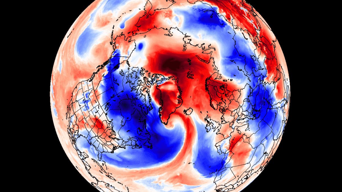
A strong “heatwave” is developing in the Polar circle, with surface temperatures up to 30 degrees above the long-term average. Strong pressure systems are driving a large air mass transport event, bringing warmer than normal temperatures into the Polar regions.
Strong pressure systems in the sub-polar regions are creating a “wind tunnel” from the North Atlantic into the Polar Circle. Now, a strong movement of air is underway, creating unusual weather conditions both in and out of the Polar regions.
As you will also see, one of the factors that even allows such strong anomalies is also the Gulf Stream and the entire Atlantic Ocean circulation (AMOC).
SPRING BEGINS
Looking first at the global temperature anomalies for March so far, we can see a large area of warmer than normal temperatures over the western Polar regions. As the warmer air moves into the polar regions, it usually means that colder air moves out.
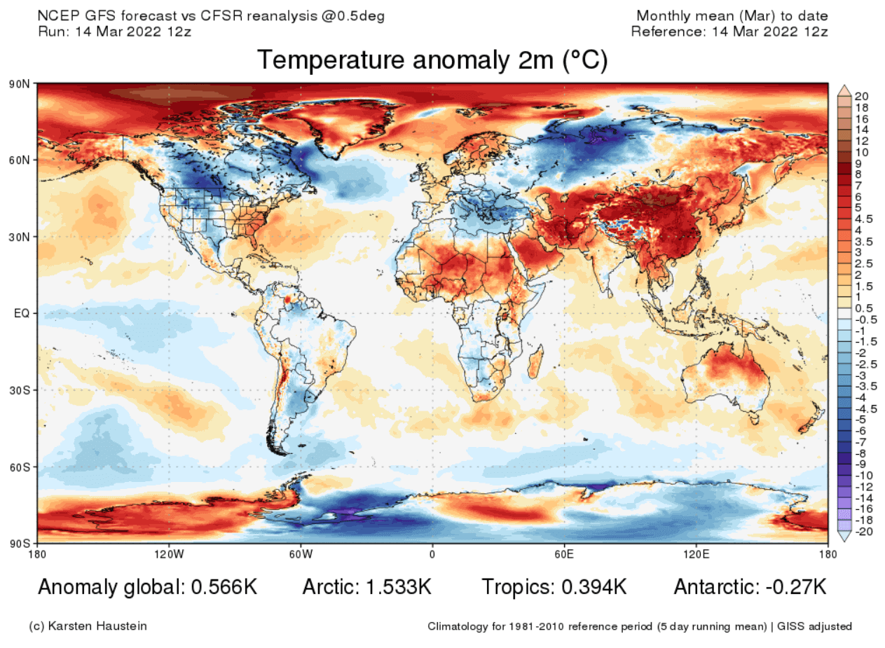
We can see that, as colder than normal temperatures can be found in most of Canada, most of west-central United States, and over parts of Europe and Siberia.
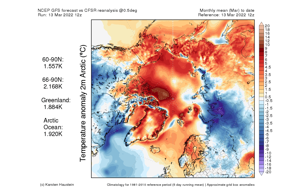
Looking closer at the polar circle, we see most of the Arctic is experiencing warmer than normal temperatures this month so far. We can better see how the warm polar regions translate to colder cub-polar regions.
Focusing on the high North Pole, 2022 so far has been warmer than normal. This is the high-resolution analysis from ECMWF data, showing current temperatures being more normal in mid-April. Image by Zack Labe.
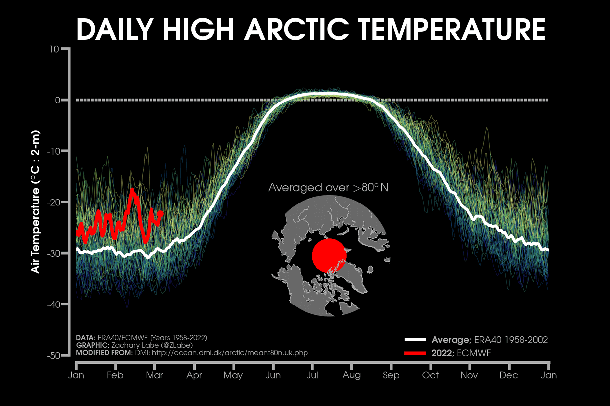
But this graph is likely to receive a large spike in the coming days, as a strong anomalous pressure/wind event is unfolding over Greenland and the North Atlantic.
PRESSURE DRIVES THE WEATHER
The atmosphere is constantly in motion and always trying to achieve a state of perfect balance or equilibrium. It is being “imbalanced” by the large temperature differences around the world, from the equatorial to the polar regions.
These temperature differences cause large pressure variations in the atmosphere, resulting in strong pressure systems around the world. The atmosphere always tries to balance out the pressure differences, which we can feel like the wind.
Below is a 3-day pressure anomaly forecast over the Polar circle. It reveals a powerful low-pressure complex over the Canadian Arctic Archipelago and Greenland. It is contrasting against a very large high-pressure zone expanding from northern Europe into Siberia.
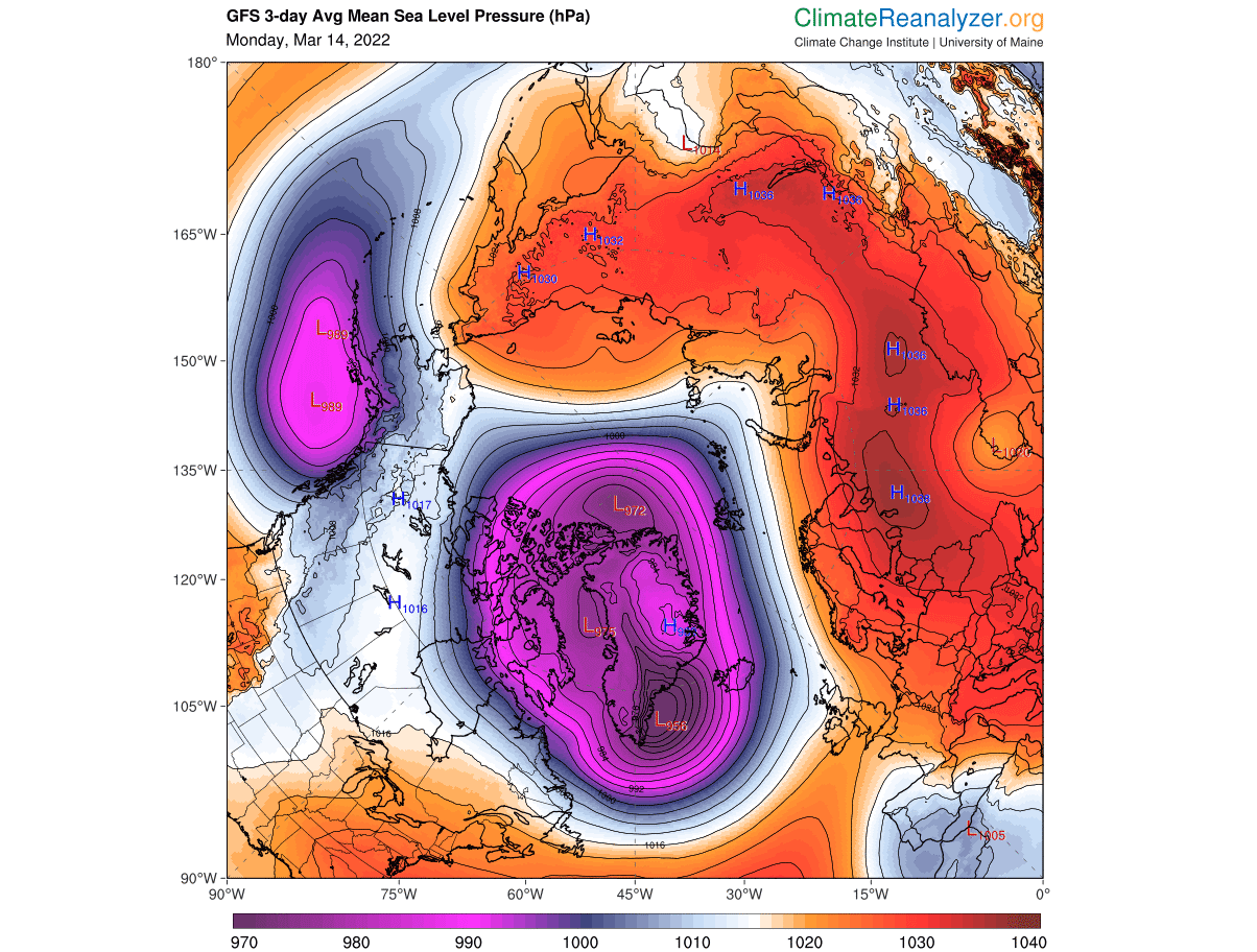
Another (much weaker) pair of pressure systems can be found with the high-pressure over the western United States and low-pressure in the North Pacific.
As we now know, the wind is the main force that is generated by the imbalance in pressure. The image below shows the 5-day wind forecast. We can see a large wind field south of Greenland, as a strong low-pressure system passes there.
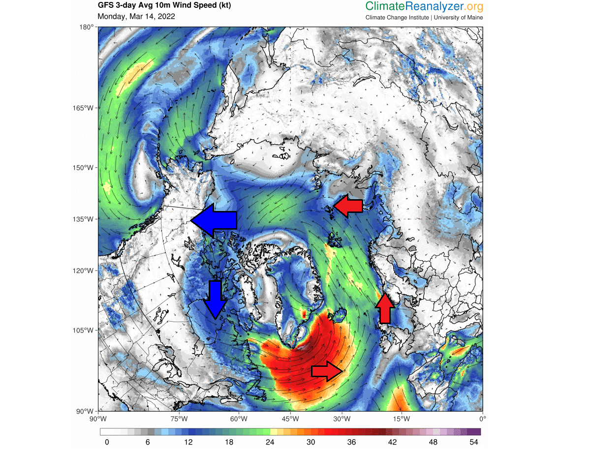
But our focus is on a wind corridor further to the northeast. You can see a stream wind from the far North Atlantic reaching into the Arctic Ocean. That is the wind corridor between the high and low-pressure systems, driven by the pressure difference.
Looking at the past few days, the ECMWF analysis shows the buildup of this event. Warmer than normal air was already moving into the polar regions, and you can see the airflow arrows. Note the colder air over much of Canada and the United States.

Such strong and persistent winds can transport a large mass of air in a very short time. In most cases, the air mass is moving too fast to adjust its temperature to the surroundings. That means that it is not warming or cooling fast enough.
Simplified, this means that large masses of air can be quickly replaced or transported without much immediate change in their temperature or other properties. This is why we see warm temperatures in the North Pole or Arctic cold air down in the mid-latitudes.
Such rapid transport of an airmass that retains its properties (temperature, humidity,…) is commonly called an advection.
On the image below we have the 3-day maximum temperature forecast, for the high Northern Hemisphere. What stands out is the temperature corridor of positive temperatures spanning from the North Atlantic into the Polar Circle. You can see nicely how the warmer temperatures “cut” into the Arctic regions.
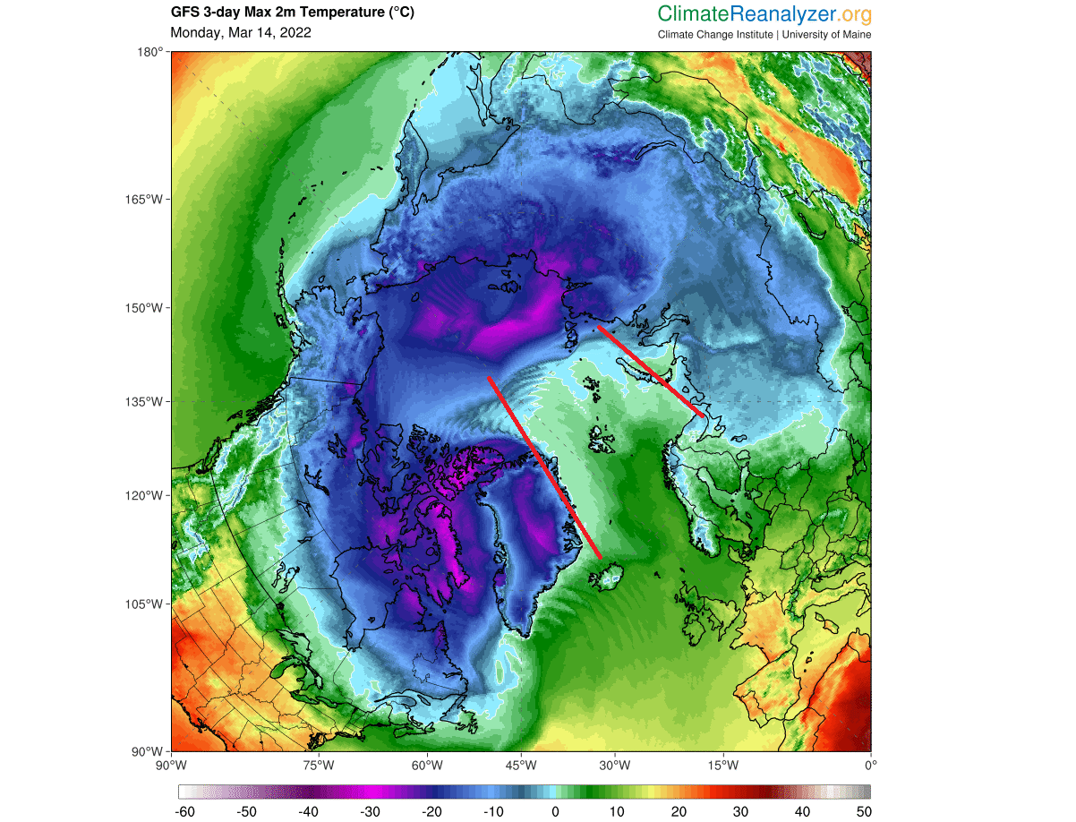
This is the warm air being transported by the strong winds that we have seen above. Note that the temperature scale is Celsius, and thus the melting point is above zero.
We produced a high-resolution video below, which shows the temperature forecast for the Northern Hemisphere. It nicely reveals the motion and development of this strong warming wave as it moves from the North Atlantic into the Polar Circle.
THE COLD SEASON HEATWAVE
We now know what is behind this wave of warmer temperatures. But we will look closer at the pressure patterns and the actual temperature anomalies unfolding in the coming days.
On the latest pressure pattern below, we can see a large, deep low-pressure system over northern Canada and southern Greenland. This system is riding on the polar jet stream, connecting back into western Canada and the North Pacific.

Another key to this story is the high-pressure ridging over northern Europe. This creates a strong pressure difference with the northwest Atlantic, starting a strong large-scale movement of air (advection). The North Atlantic air mass is being transported up north into the Polar Circle.
Looking at temperature anomalies, we can see a large area of unusually warm temperatures inside the Arctic. This is the air transported on a massive scale mostly from North Atlantic. As a contrast, this means that the colder Arctic air moves out into Canada and western North Atlantic.
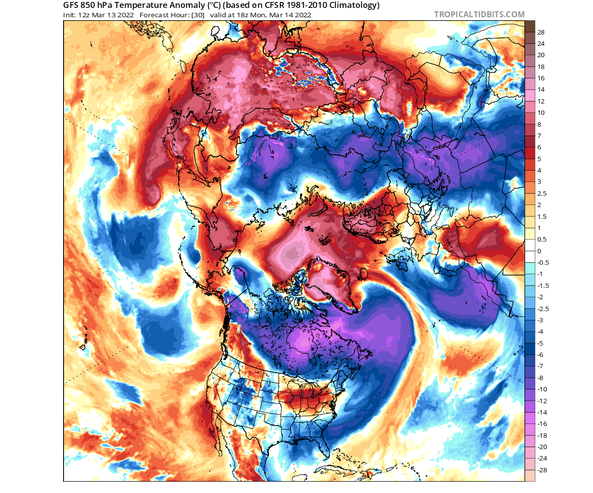
In the image below, we have a combination of surface temperature anomalies and winds. We can see strong southerly winds from the North Atlantic, covering over the warm anomalies. Northerly winds transport the colder air out into Canada and Siberia.
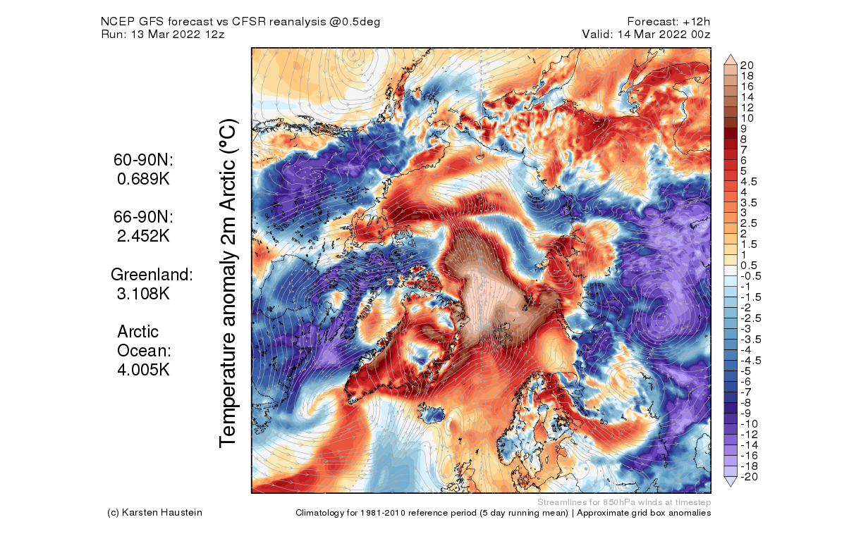
Looking more closely at the 2-meter temperature anomaly, we can see temperature anomalies reaching over 30 degrees Celsius above the long-term average. This is a significant anomaly, indicating unseasonably high temperatures over that part of the Arctic.
The real significance of these anomalies shows in the percentile ranking. This basically shows where the temperatures rank from a historical perspective. As we can see, this “heatwave” is reaching record high temperatures for this time of the year.

As such, this is of course not a heatwave, like during the Summer. But considering the unusually high temperatures for this region at this time of the year, it is in essence a heatwave of warmer than normal temperatures.
HEATWAVE INTENSIFIES
Looking at mid-week, we have the sea-level pressure anomaly forecast below. You can see the low-pressure area has now moved further into the Polar circle, and the high-pressure system over northern Europe has intensified.
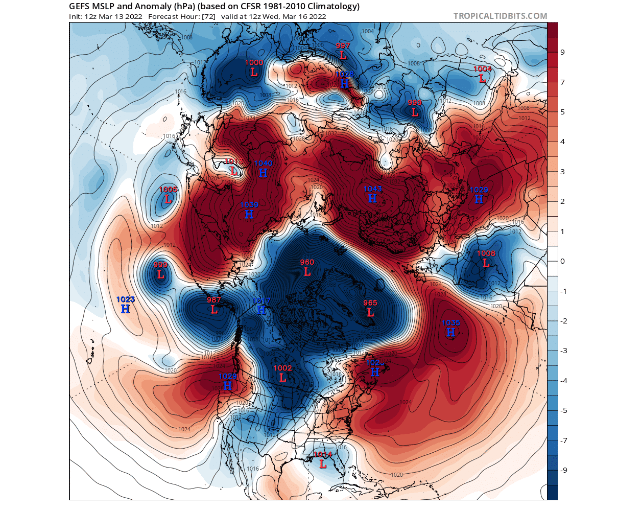
This means an even stronger (final) burst of southerly winds. That results in a larger area of warm anomalies, continuing to exceed 30 degrees Celcius above normal.

On the temperature/wind combo image below for mid-week, we can see the broad southerly wind field. This is creating and driving a large transport of warmer air mass from the North Atlantic, now covering an even larger area.

Looking again at the temperature percentiles for mid-week, we can see the unusual anomalies now covering an even larger area. Core parts of this large air mass are still creating near record-high temperatures for this time of the year.

We can also see colder temperatures being transported into the western North Atlantic, reaching near-record low values for this time of the year.
This strong event is expected to last at least by the weekend. Below we have the pressure anomaly forecast by the ECMWF model, showing the low-pressure system now completely over the Polar Circle. This still drives the strong southerly winds and warmer anomalies from the North Atlantic, but at a reducing rate.

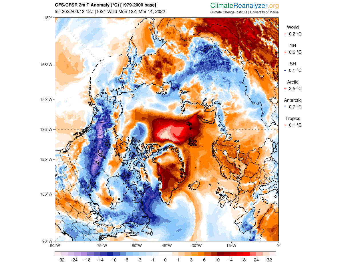
Looking at the surface temperature anomalies from ECMWF for the same period, we see the sustained warm anomalies. Peak temperature anomalies are still reaching up to 20 degrees above normal.

What is different tho, is the reduced output of colder air down into North America. We can now even see warmer than normal temperatures over western Canada and also over eastern and the northeastern United States.
WARM TO COLD
Newton’s third law of motion states that “for every action, there is an equal and opposite reaction”. Tho not being designed specifically for weather, we now know it applies to weather too. When we see this warming over the Arctic, an opposite, cold reaction is occurring somewhere else.
That is exactly what we see when we look at the mid-week temperature anomaly forecast over the Northern Hemisphere. Continued warm anomalies in the Arctic and the movement of colder air out of the Polar regions.

The cold air anomalies that you see above surrounding the Arctic, are essentially sourced from that region. It gives an impression as the cold air is being pushed out by the warm wave.
In reality, it is not really being pushed out but is actually is actively transported out of the Arctic, and replaced by this unusually warm air. A similar force that is transporting the warmer air into the Arctic, is also transporting the colder air out.
With a very impressive warming wave and much higher temperatures than normal, the first question is what the impact on the sea ice is going to be. The Arctic sea ice melt season has just begun.
Temperatures are more than 20-25 degrees above normal on a large scale in the region. But with normal temperatures around -20°C to -25°C, that still means actual temperatures around zero or slightly positive.
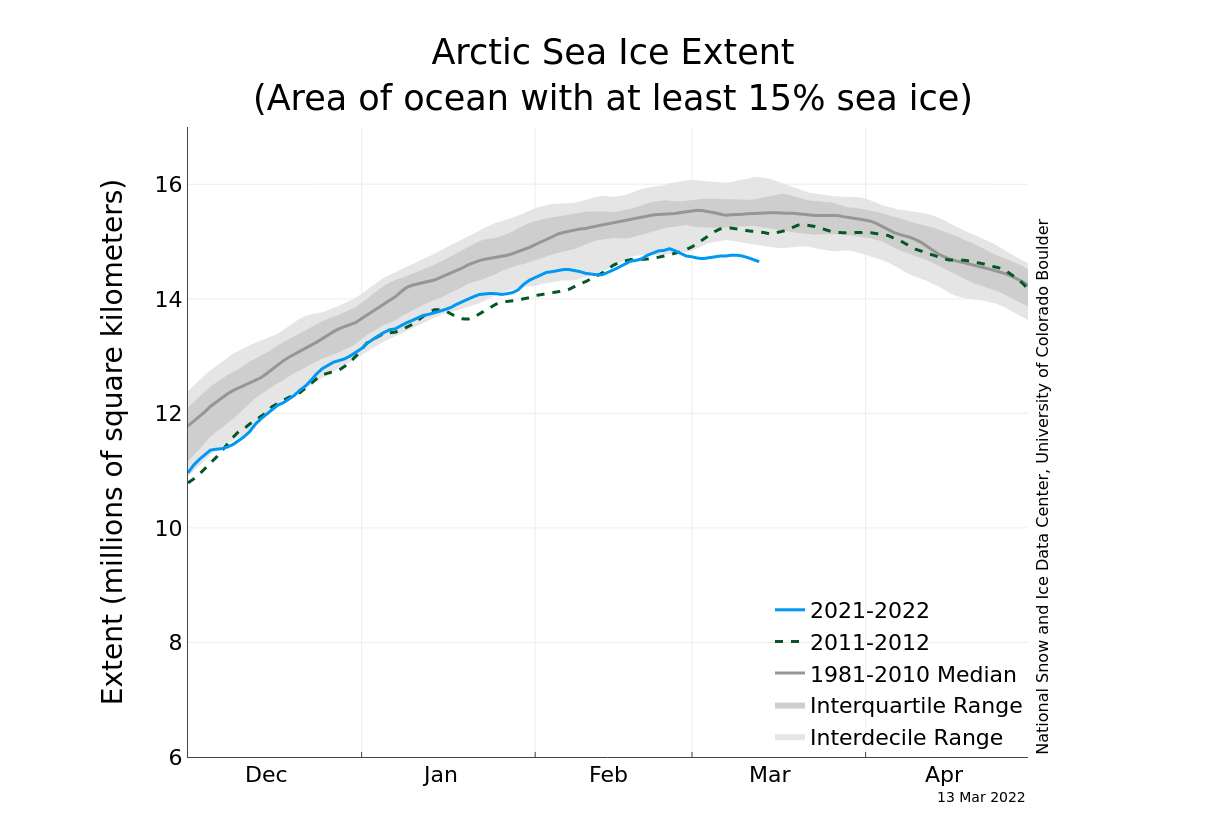
The current Arctic sea ice extent graph shows that the sea ice has reached its peak in late February, by the latest data. March so far has already seen a reduction in the sea ice extent. And with such anomalies coming into the Arctic, we can expect some more melt in the outer edges.
Below we have the latest sea ice thickness data. The outer edges of the ice sheet are of course always the thinnest, as they are constantly freezing and melting. And with the strong warm anomalies now developing, these are at the highest risk of being melted sooner than usual.
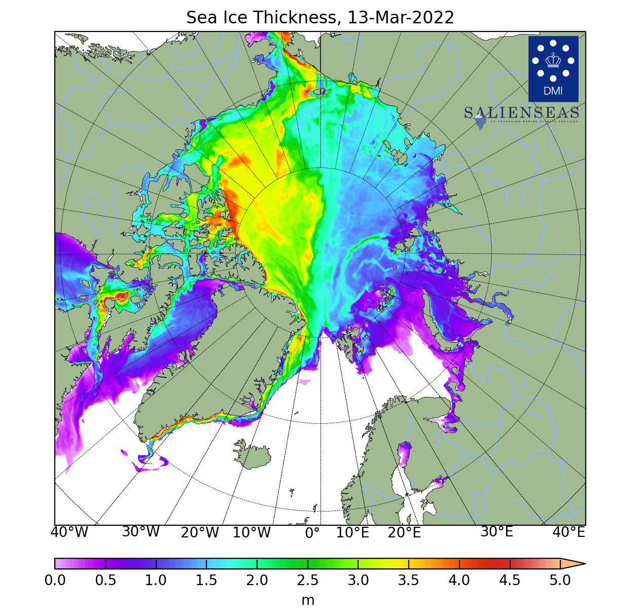
The sea ice surrounding east and south Greenland is thicker and not prone to melt in a few days of warm anomalies. But further east, we have the thinner outer edges of the ice sheet, which are prone to melting faster than normal in the coming days.
GULF STREAM AND THE ARCTIC
But one important factor of this “heatwave” is the infamous Gulf Stream and the Atlantic Ocean circulation. Let’s take a look at the region which helps to support such a strong temperature wave in the first place.
A lot of these “warming” waves enter the Arctic region from the North Atlantic. The loosely used term for this transport region is “The gates of North Atlantic”.
There are no actual doors in nature, but this term defines a region or a corridor from the North Atlantic towards the Arctic, where warmer ocean waters are being transported.
The image below shows the sea surface temperature of the North Atlantic ocean. It is nicely seen how warm the far North Atlantic ocean actually is, with temperatures around the British Isles ranging from 10-12°C. This is not particularly warm but is quite mild for the late cold season.
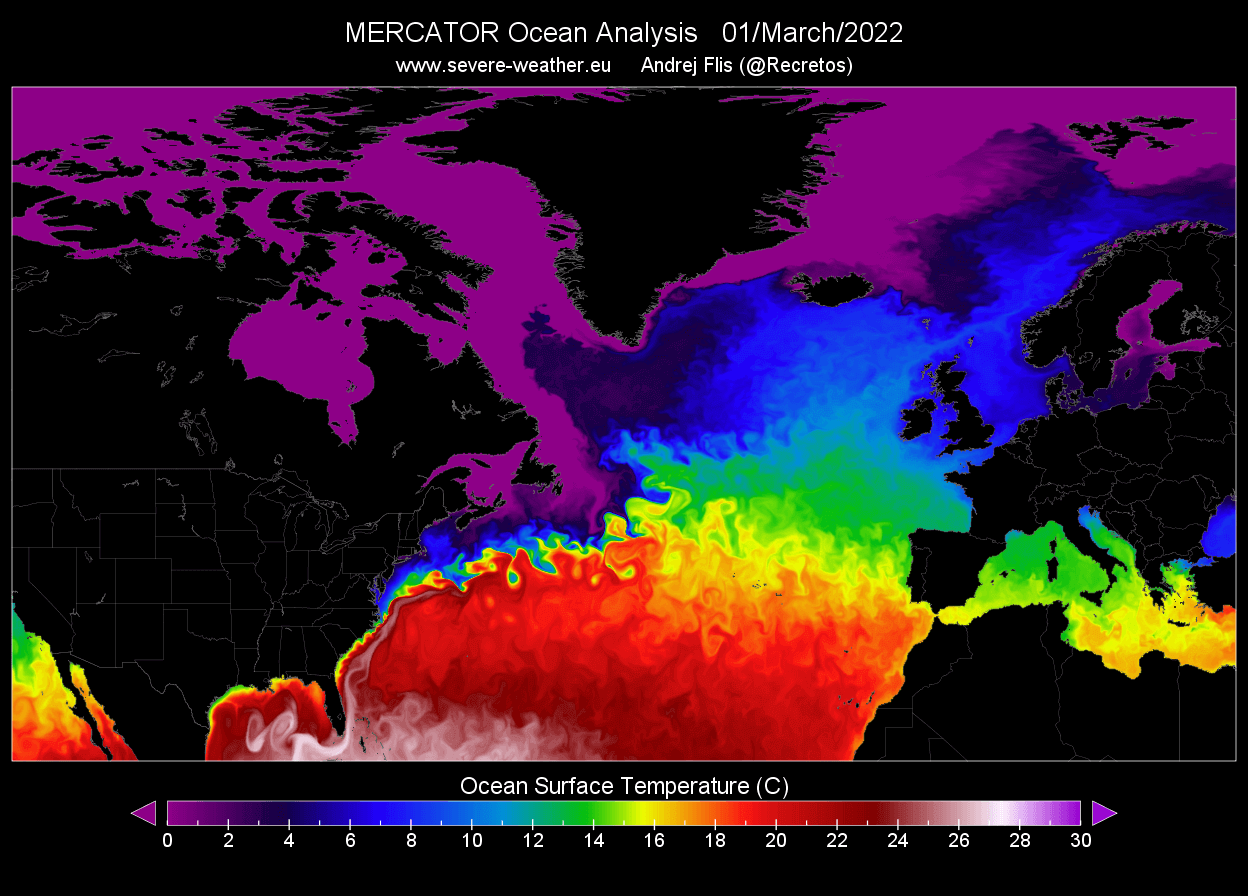
We can also see above, how the positive temperatures continue far towards the north, with 6-8°C sea temperature going up to Scandinavia. Positive temperatures of 2-4°C actually reach the Arctic regions.
The latest analysis of ocean temperature anomalies actually shows warmer than normal ocean temperatures in the Norwegian Sea and Greenland sea. Also note, much of the North Atlantic is warmer than normal for this time of year.

But positive ocean temperatures do not cause +20°C anomalies over the Arctic on their own. Instead, they help to keep the surface air temperatures relatively warmer for a longer period of time before reaching the Polar Circle.
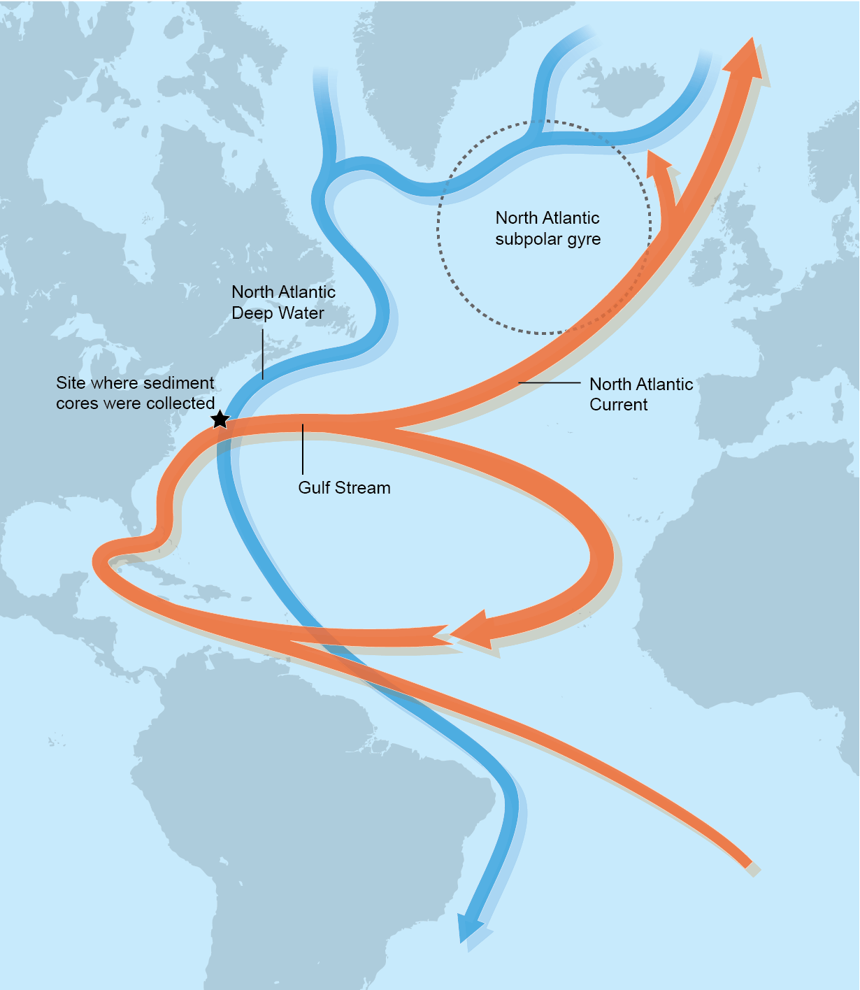
The main reason the ocean stays so warm in winter, with positive water temperatures even in the Arctic, is the AMOC. Also known as the Atlantic Meridional Overturning Circulation.
This is the main oceanic circulation system in the North Atlantic. It is quite famous since it is well known that this ocean transport system enables milder weather conditions for northwest and northern Europe and the east coast of the United States.
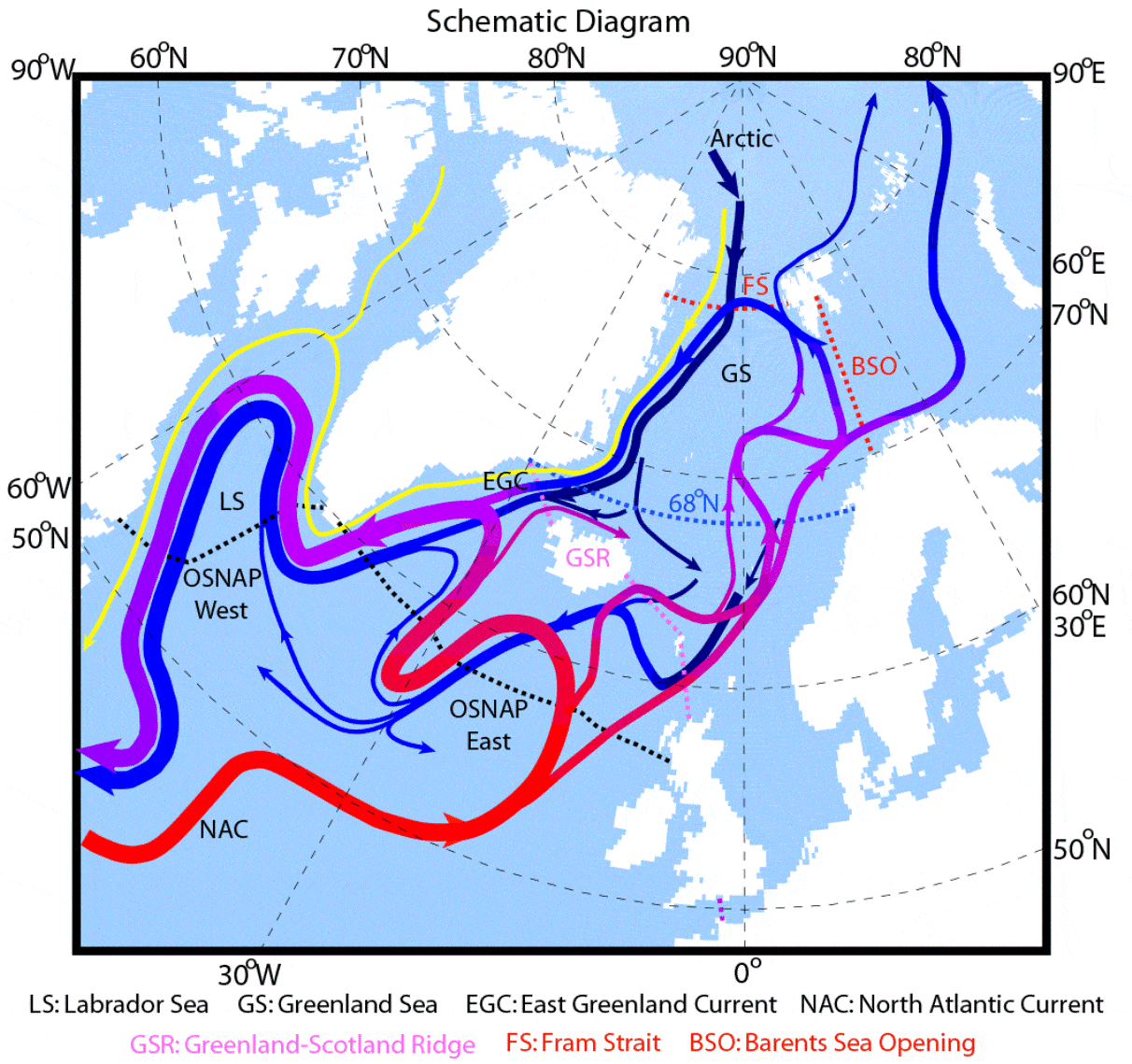
It actively transports warmer ocean waters from the south up towards the north, as seen in the graphic below.
Probably the most well know part of this system is the Gulf Stream. We produced an image below, which shows the actual surface current analysis. The strongest currents can be found in the Gulf Stream, which is moving up along the east coast of the United States.
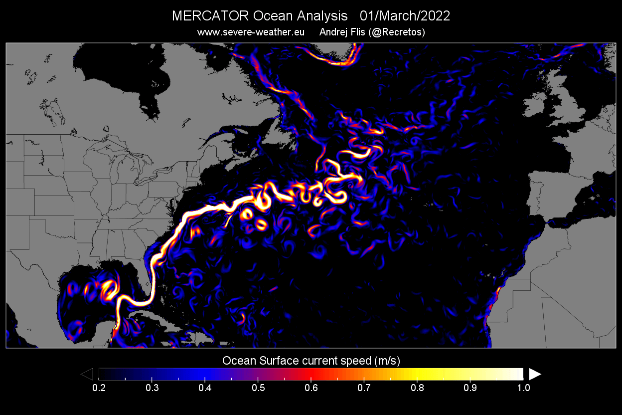
It then turns east, further into the North Atlantic. Then it continues further north, pushing through “The gates” between Iceland and the British isles and eventually reaching the Arctic.
This active water transport system is one of the main reasons that the North polar circle is mainly ice-free in this region. Below we have an image, which shows the warm ocean currents extending from the Gulf Stream in the North Atlantic into the Polar Circle.
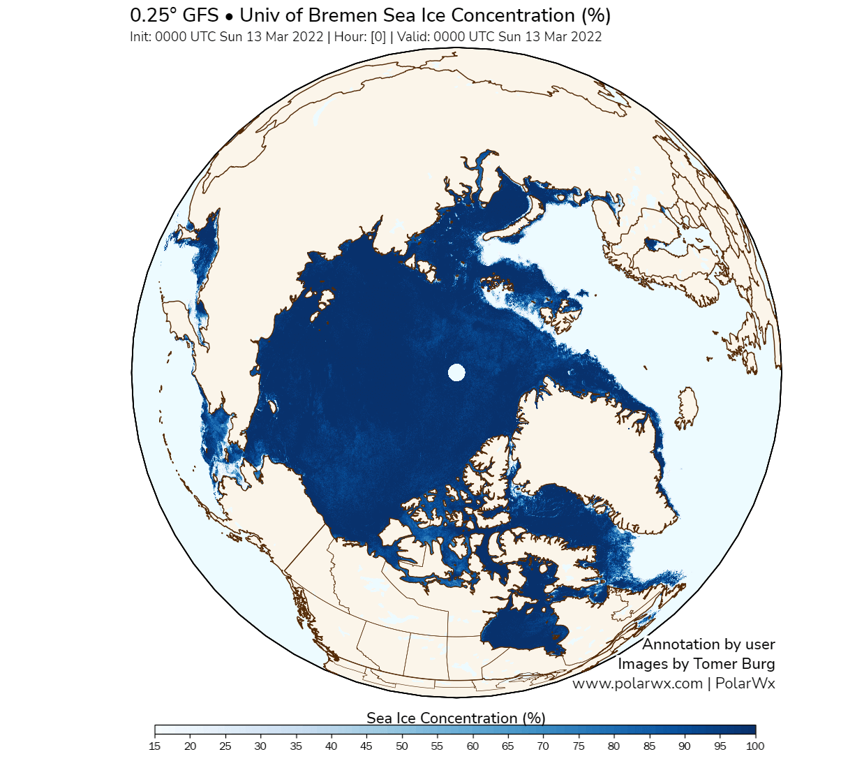
It is nicely seen on the sea-ice concentration analysis below, how the region connecting to the North Atlantic is ice-free. That is due to the ocean temperatures being too warm to allow freezing. The active ocean currents are constantly delivering relatively warmer waters, preventing thick sea ice to form.
We will keep you updated on similar nature and weather events around the world, so make sure to bookmark our page. Also, if you have seen this article in the Google App (Discover) feed, click the like (♥) button to see more of our forecasts and our latest articles on weather and nature in general.
SEE ALSO:
The Nor’Easter Winter Storm Quinlan becomes the deepest Bomb Cyclone of the cold season