Normally, it takes some time for NASA's Mars rovers to return scientific data. The instruments need to be calibrated and commissioned, and the rover needs to move off the landing site toward a piece of landscape with clear scientific interest. In the case of the Perseverance rover, there was an added delay as it tested out the Ingenuity drone over the course of several weeks.
But this week brought a pleasant surprise: The first research paper from Perseverance was published in Science. It turns out that some of the early photographs from the rover revealed features in some near-vertical rock walls some distance from the landing site—details that tell us about the history of the flow of water into Jezero Crater.
Mars meets Kodiak
The Jezero Crater was chosen as Perseverance's landing site because images taken from orbit indicate it once hosted a lake. The photos revealed an exit channel that allowed water to flow through a gap in the crater walls and a site where rivers flowed in to feed the lake. There was also what appeared to be a river delta spreading into the crater from these sites. The rover's mission profile includes sampling material from that delta, which might once have been an inviting environment for life and would have collected any living material that existed upstream.
A key part of the mission is confirming that the deposit was, in fact, produced by a river delta. That's what the new paper is about, and it goes considerably further by revealing what type of delta formed the deposits near the rover's landing site.
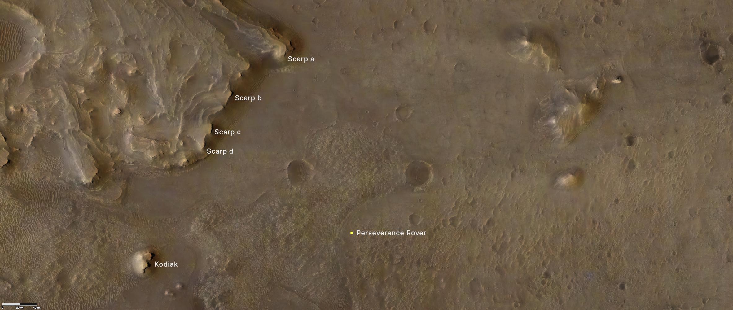
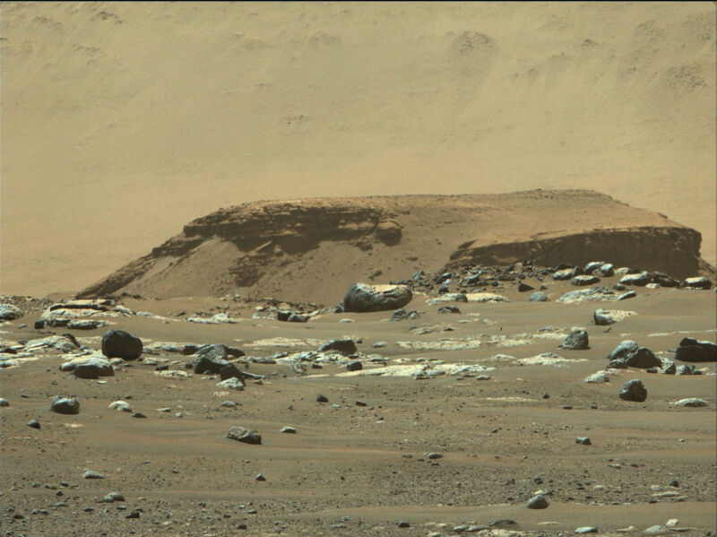
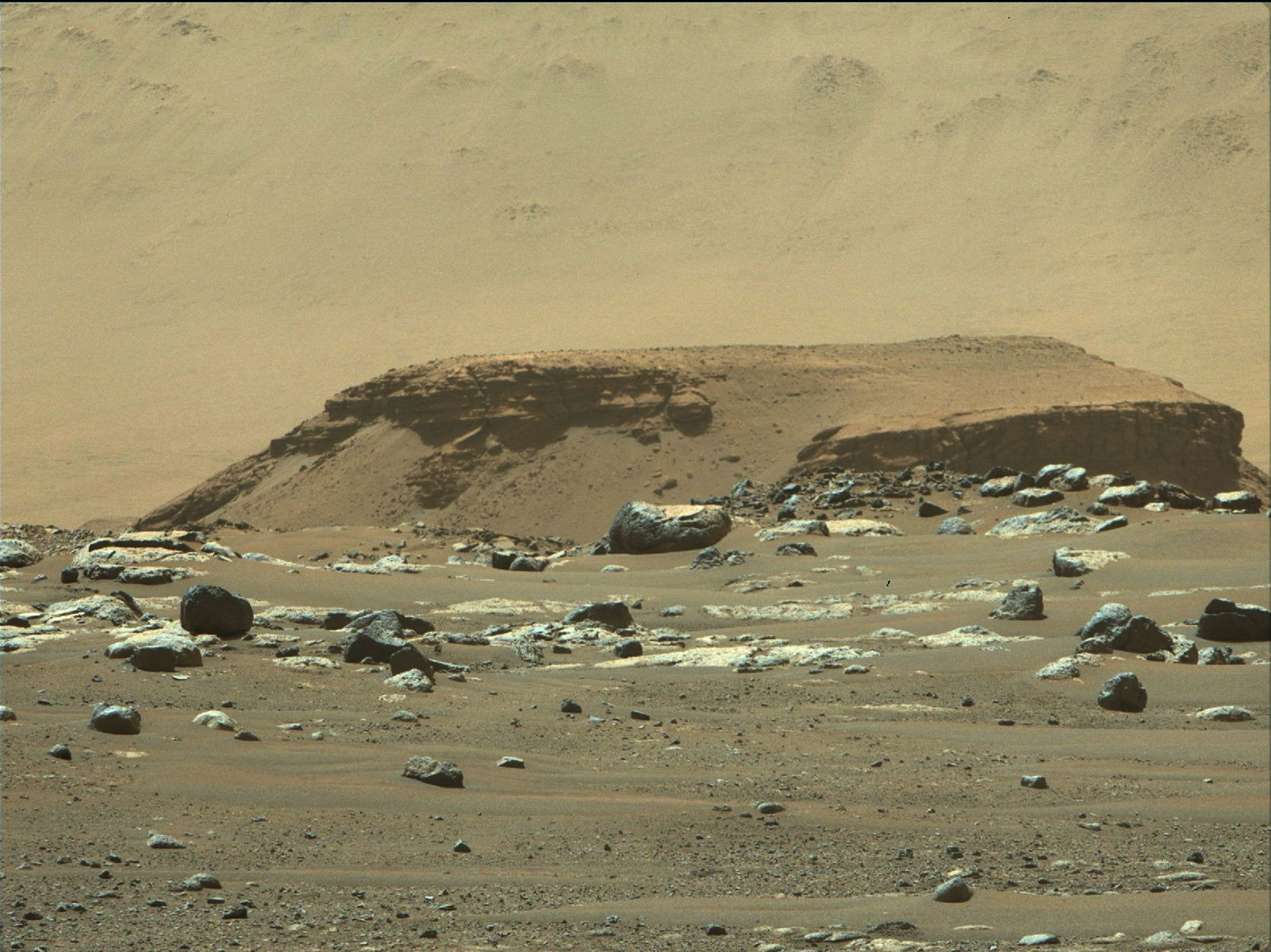
The key to the discovery is a feature that has picked up the informal nickname "Kodiak," a butte that's located almost due west of Perseverance's current position. Its height relative to the crater floor is about the same as that of the larger delta fan that is contiguous with the crater wall, indicating that they were once part of the same formation but that the material that connected them has since eroded away.
Critically, on the larger delta fan, details of the former delta's structure are covered by mounds of rubble, making them difficult to interpret. By contrast, on Kodiak, some of the delta deposits are clear of the rubble, meaning they can be observed. And since those rocks are nearly vertical, it's impossible to see them from orbit. But Perseverance was able to obtain some excellent images of them, and they turned out to be very revealing.
Parallel lines
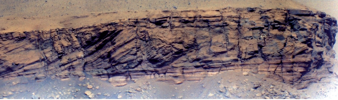
In areas of Kodiak that aren't covered by rubble, it's possible to detect the general trends in the layers of sediment deposits that now form the body of the butte. And these layers show a consistent pattern. At the base, the layers are nearly flat or gently sloping. Above that are areas where the layers are significantly tilted toward the vertical. And that section is topped by a second set of roughly horizontal layers.
These sorts of deposits, which form as the result of river deltas, have already been described on Earth. The lowest layers form at the bottom of a lake as new sediment is carried in and settles roughly uniformly. As the elevated delta starts to move farther into the lake, deposits tilt toward the vertical as sediment slides down the slope formed at the edge of the delta. Once water is flowing across the top of the delta, sediment again starts to form roughly horizontal layers.
For this to happen, the water levels in the lake have to be reasonably stable for a relatively long period, although how long will depend on how much sediment the incoming water carries. In the case of the Jezero Crater, however, the left and right sides of Kodiak reveal similar deposits at two different altitudes from the crater floor. Since Mars isn't tectonically active enough to have split the formation, this suggests that the lake was stable in at least two different depths at different points in its history.
The researchers who analyzed these photos also note that neither of these levels seem to match up with the height of the apparent outlet channel in the crater wall, which suggests that waters sometimes reached a third elevation.
That third elevation, however, could have been reached during dramatic floods. At the top of the delta, there are deposits that include large, rounded boulders, suggesting they were moved along by floodwaters. So late in its history, after the delta deposits were in place, Jezero Crater was probably the site of some violent floods, possibly including events that occurred after the lake itself had gone dry.
There's obviously still a lot of detail to fill in. But remember, all of this information came from a handful of photos taken early in Perseverance's stay in the crater. With time, the rover should have the chance to examine some of the deposits up close to give us a clearer picture of Mars' history.
Science, 2021. DOI: 10.1126/science.abl4051 (About DOIs).
reader comments
111